Frittenden through the ages
FRITTENDEN’S EARLY HISTORY
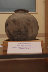
The earliest documentary evidence of Frittenden comes from a Saxon charter of 804. However, there is archaeological evidence of activity from the Roman era, with the discovery of two Romano-British urns discovered in Leggs Wood in 1857. Leggs Wood is close to Knoxbridge, where the Roman route from Rochester to Hastings runs. These urns can be seen at Cranbrook Museum.
ORIGIN OF THE NAME
The origins of the name Frittenden are unclear. The den element of the name indicates that it was an area providing temporary pasture, probably from the sixth century, on an annual basis for swine driven down from a place in north Kent. (It is possible that this pasture would have been recorded as a possession of the north Kent place in the Domesday Book). The derivation of the first part of the name is less clear. It may have
come from the name of the name or ‘free coerl’ who used the den, possibly one named Frith. A record from the fourteenth century records the name as Frithyden, which supports this theory.
FORMATION OF THE VILLAGE
Early documentary evidence suggests that the early permanent settlements
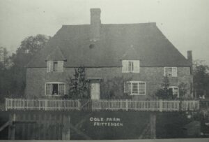
were on the ridge above the flood plain. The church also stands on this ridge and is first recorded in the White Book of St Augustine’s c1200. By the thirteenth century, dens were becoming satellite communities of the manors to which they belonged. Cole Farm, c1400, is the first surviving indication of settlement in the flood plain. The 1524-5 tax
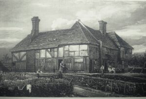
subsidy suggests that the Weald had seen great prosperity during the previous 200 years. This is reflected in the number and quality of medieval listed buildings in the parish. The 1806 and 1839 tithe maps show that the village consisted of two main nuclei, the first grouped near the church and the other around the Bell Inn and the forge. Since
then these two areas have been linked by new building.
FROM HASTED
In his History and Topographical Survey of the County of Kent (pub. 1788-1799), Edward Hasted is less than complimentary about the village:
“This parish is very narrow from east to west, and contains about seventy houses. It has an unpleasant and forlorn aspect. The foil is a deep, stiff clay, very wet and unkindly for tillage, insomuch that, in a rainy season, the occupiers have but little produce form their lands, which consequently keeps them very poor. The southern part of it is entirely covered with coppice wood; besides which, the staves are frequent, and the hedgerows broad around the fields, which have quantities of large oak trees interspersed throughout them. The roads, from the soil, except in the driest season, are so deep and miry, as to
be almost impassable; though it lies so obscure, that there is but little traffic through it. The village, which is but small, stands on a hill near the middle of the parish, and the church close to it. “
THE IDENDEN CHARITY
Following the dissolution of the monasteries by Henry VIII there was an explosion in the creation of charities. In 1566, under the will of Thomas Idenden, a charity was established for “the use of the Poor Maidens Marriages, to the relief of the poor Householders” in
Frittenden. The property left to support this charity was later to become the parish workhouse and farm. The charity disposed of the property in 1953 and the house is now known as Charity Cottages. The charity continues to make small payments to certain parishioners on St Thomas’ Day.
AGRICULTURE AND INDUSTRY
Farming in the parish has normally been a mixture of pastoral and arable, though the balance has changed considerably over time, notably in the depression following the Napoleonic War when there was a significant movement into arable. This resulted in a longer and deeper depression, well into the 1840s, than might otherwise have been the
case. In 1851, Reverend Moore estimated that ‘some 200 souls’ must have emigrated to America from Frittenden in the course of the previous 30 years. This must have had a significant impact on the village, which had a population of just 804 recorded in the 1841 census.
Frittenden was on the margin of the cloth making area centred around Cranbrook and probably benefited from proximity to this industry. A history of Cranbrook’s cloth trade relates that cloth-workers from Frittenden joined with others from Cranbrook and Goudhurst in an unsuccessful plot to overthrow Cardinal Wolsey during Henry VIII’s
reign. There were other instances of Frittenden men being involved in rebellions: John Atte Berche, Junior was listed in a parliamentary roll as being one of the ‘prominent leaders’ from Kent of the 1381 Peasants’ Revolt; and Stephen Hogge, a gentleman, obtained a pardon for his involvement in Jack Cade’s rebellion of 1450.
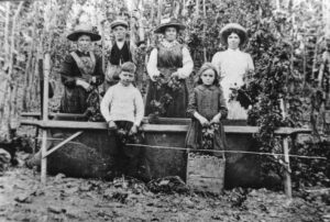
Hops, always a risky crop, became a major crop during the nineteenth century and into the twentieth, but no hops are grown in the parish today. The Cornwallis estate had a small brickworks in Dig Dog Lane and this remained open until the 1970s. Bricks and tiles from this site were used in many nineteenth and twentieth century buildings in the village.
ST MARY’S CHURCH
Hasted describes the church as describes consisting of “two isles (sp) and two chancels, having a spire steeple, in which are fix bells. It is dedicated to St Mary. In the chancel is a monument for the Rev Henry Bagnall, rector, 1761, arms, Barry of four, or, and ermine; all over, a lion rampant, azure; and a memorial for Elizabeth, sole daughter and heir of Robert Perry, gent of this parish, obt. 1646, aet, 178; arms, On a bend, three spears.” He says that in 1578 there were 156 communicants.
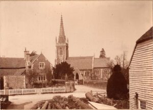
The Church was almost totally rebuilt by the Reverend Edward Moore and rededicated in 1848. Edward Moore, together with his wife Harriet, had a major impact on the village and indeed on how it looks. Their hand can be seen not only in the church, but in the creation of the school, a Provident Society, a Penny Bank and much else besides. Edward Moore, was a major landowner, second only to the Cornwallis Estate. He was also responsible for many buildings in the parish, including the creation of Parsonage Farm, the largest farm at that time.
MODERN HISTORY
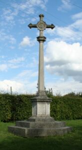
The village war memorial records the names of twenty-three men who gave their lives in the First World War. This list includes the rector of St Mary’s, the Reverend Rupert Inglis who did not feel he could encourage others to serve and not do so himself. He was killed while helping gather the wounded from no-man’s land during the battle of the Somme.
There are a further ten names listed on the memorial to commemorate those who died during the Second World War. This includes the Millen brothers, Andrew and David. Andrew was killed during the Battle of Anzio in 1944 and David was killed when his MTB was sunk off Tobruk in September 1942.
On 15th September 1940, towards the end of the Battle of Britain, a Heinkel HE111 was shot down over the village. One crew member died, but the other four were captured. A painting of the incident and one of the plane’s propellers are on display in the Bell and Jorrocks pub.
